Through the Ruins of Eastern Turkey
First of all, I want to acknowledge something. What we saw on this trip will not last forever. If my great grandchildren visit Eastern Turkey, they will find fewer traces of a past Armenian (as well as Greek and Assyrian) presence than we did. The ruins will be fewer, the outlines fainter, and the carvings thinner. And some places will be completely gone. What can still be touched today may one day exist only in photographs and in the words of those who took the time to record it. An example of this is city names. (Note 1)
And that is one reason I am writing this. Documenting this trip is a small form of preservation. And for the 95% of Armenians from the diaspora who will never set foot in the villages their great grandparents fled from, all they have are stories like these. For them, these places exist only in black and white photographs and in documentaries.
I am not from these towns myself, but my friends are. And so we decided to go see them.
The purpose of this trip was to simply see everything Armenian. To walk where Armenians once walked, to stand among the stones they placed, and to witness the landscapes that once surrounded their homes. If there was beautiful nature along the way, we stopped. If there was a beautiful mosque, we stopped. Because Turkey is a beautiful country, and it holds a rich culture, even if that culture rests on a foundation that refuses to acknowledge its past.
What Turkey Does Not Show You
Secondly, something I learned firsthand during this trip, is that Turkey does not invite you to notice the Armenian past. Often, all we had were Google Maps pins to follow, leading us to seemingly random places that felt like they were waiting to be repurposed or erased (probably through abandonment or neglect).
Signs point elsewhere, museums and official placards mention other empires, and any link with Armenians is conveniently downplayed or completely omitted.
A fallen church is not just stones on the ground. It is a witness that can no longer testify.
Without these tangible reminders, the story of Armenians in these lands will rely more on written records and memory, both of which are easier to ignore and forget.
Beginning our Trip
The Trajectory
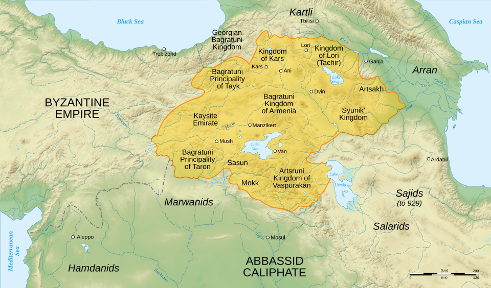
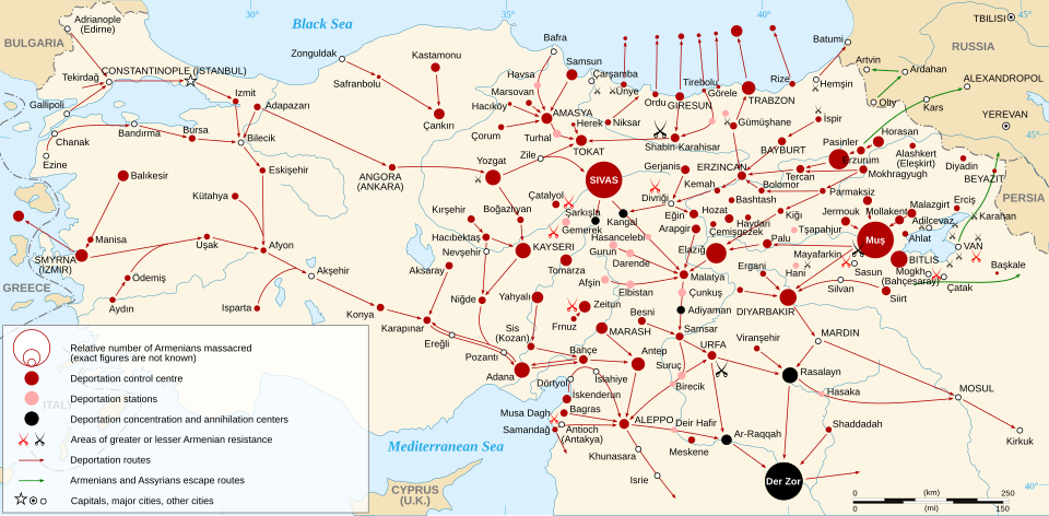
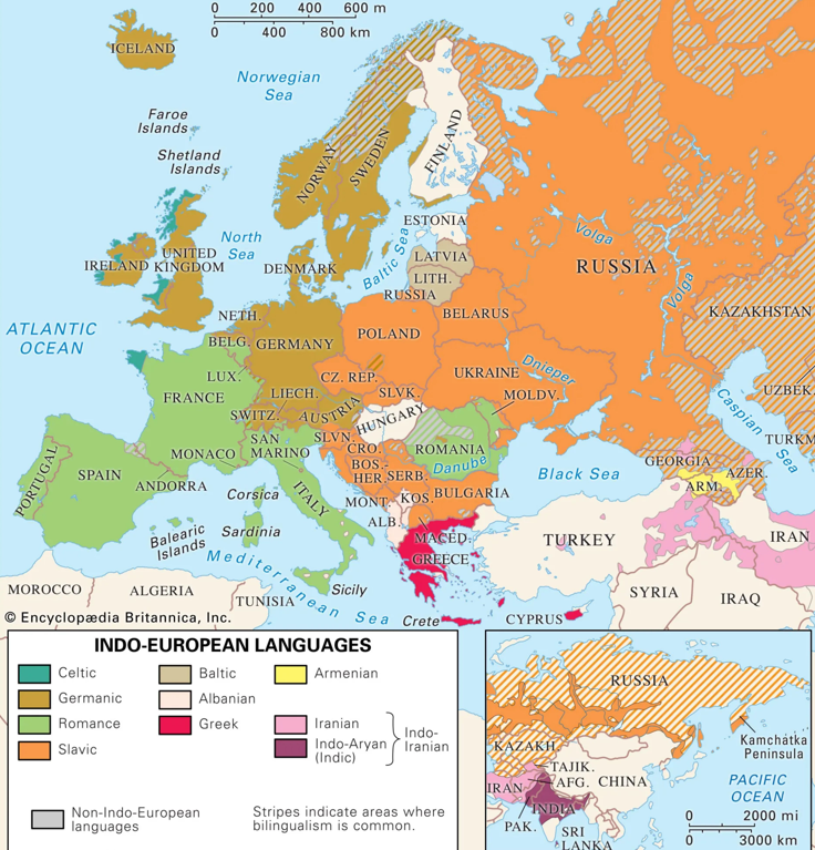
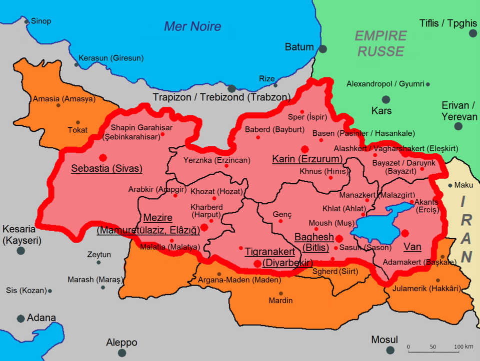
First of all, keep in mind this map:
.png)
This is a map of the percentage of Armenians in various regions of the Ottoman Empire before the genocide. Look into the six vilayets of the Ottoman Empire for more details.
As Armenians we intuitively know this map, because we hear from our surroundings “my father’s side is from Bitlis”, “my maternal grandmother’s side is from Kars”, “my grandparents are both from Mush”, etc. We hear the names of all these places. So over time we may pick up some patterns.
Anyway, here is the trajectory we took:
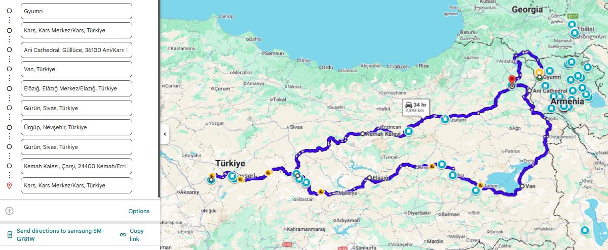
We passed through the following cities:
Gyumri, Kars, Ani, Iğdır, Van, Akthamar Island, Bitlis, Muş, Yukarıyongalı (tiny Zaza village), Elâzığ, Harput, Malatya, Gürün, Kayseri, Ürgüp (Cappadocia), Gürün, Kemah Gorge, Erzincan, Erzurum, Kars, Akhalkalaki, Gyumri.
The best way to get to Eastern Turkey from Armenia is by land, through the Georgian border. So we had our Armenian driver take us to the Georgian-Turkish border, from where a Turkish driver took us to Kars.
We went through the armenian portion of Georgia, and I’ll go on a little tangent about the Armenian portion of Georgia. You can read if interested. (Note 3)
I was going to write the route and every interesting thing we saw, but I decided to focus on the history of some of the places, and notes for a future trip to Turkey are left at the end.
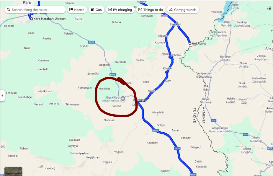
Ani
It’s funny/sad because I name other places by their Turkish names followed by the Armenian names. And this would’ve happened here if the Turkish government would change the name Ani to Anı (pronunciation changes), which they apparently did consider/attempt doing. They would’ve said that “anı” means “memory” in Turkish, which would give it a symbolic undertone. But thankfully the name Ani is too entrenched in history. At this point it would draw too much negative attention to Turkey and would bring to light all the Turkification it has done to Armenian (and others such as Greek and Arab) sites.
Ani was built during the era of Bagratid Armenia (885–1045 AD). Bagratid Armenia was a medieval Armenian kingdom founded by Ashot I Bagratuni, and it marked the first independent Armenian state after centuries of foreign rule (mostly Byzantine and Arab domination). Its capital moved around, but in 961 AD, Ani became the capital. Take a moment to look at this very important and informative link of capitals of various Armenian kingdoms.
At its peak, Ani had potentially 100’000 inhabitants, rivaling Constantinople and Baghdad in beauty and wealth. At this point I should note also that although it is named “the city of 1001 churches”, it didn’t actually have that many. As Wikipedia has it, “to date, 50 churches, 33 cave chapels and 20 chapels have been excavated by archaeologists and historians”.
In 1045 AD, Ani was surrendered without much resistance to the Byzantine Empire, who wanted this front to defend against the Seljuks. How this “surrender without much resistance” happened is actually quite interesting, with some treachery involved. Basically, King Hovhannes-Smbat I (r. 1020–1041) promised the Byzantines succession of Ani after his death. But once he died, King Gagik II (r. 1042–1045) took over and rejected Byzantine claims to the land. Gagik II wanted to keep the kingdom independent. The Byzantines tried multiple times to take Armenia by force and intimidation, but failed. Finally, since there were also Byzantine-sympathizers within the Armenian elite, they were able to invite King Gagik II (r. 1042–1045) to Constantinople under the false pretense of diplomacy, and imprison him instead. Gagik II was 19-20 at the time.
You can read more about that here and here.
In 1064 AD however, the Seljuks captured Ani and many inhabitants were killed or enslaved, and much of the city was destroyed. This was the start of the decline of Ani. (This conquest played a significant role in the movement of Armenian into Cilicia, which was officially established as a principality in 1080 AD, and was a full-on kingdom between 1198 and 1375.)
Then in 1072, the Seljuks transferred Ani to the Shaddadids, a Muslim Kurdish dynasty, as a vassal state. The Seljuk Empire was already enormous, stretching from Iran into Anatolia, and they had no interest in directly administering every distant frontier city. Instead, they entrusted Ani to a loyal local dynasty to rule it on their behalf and defend it against Byzantines and Georgians. The Shaddadids held Ani until 1199, ruling over a still largely Armenian city in which Armenian, Kurdish, and Muslim elites shared power, administration, and at times intermarried.
Afterwards, the Georgians took control, and encouraged Armenians to settle back. They even let Armenian nobles rule (Zakarid princes).
Ultimately, it all came down in 1236 AD after the Mongols entered Ani during their expansion into the Caucasus. Unlike the Seljuk’s, who massacred tens of thousands, Mongols often took cities for taxation. To be exact, they stormed Ani, killed many defenders, and looted churches and homes. Then, they imposed heavy taxes on the survivors instead of wiping the city out.
The city faced further damage from a significant earthquake in 1319, which further contributed to its decline. By the 15th–17th centuries, Ani was largely abandoned. Small Kurdish, Persian, and Turkish communities lived among the ruins.
What do we see there today? The most significant is the Cathedral of Ani (989–1001), designed by Trdat the Architect, or Trdat Chartarapet (Տրդատ Ճարտարապետ) in Armenian. Its dome collapsed in an earthquake in 1319 and it has stood roofless ever since, but today scaffolding surrounds it as part of Turkey’s restoration project at Ani.
It should be noted however that these restorations are controversial. Critics argue that Turkey often presents Armenian monuments in ways that dilute or obscure their origins, sometimes rebranding them with Turkish names or emphasizing later Islamic phases while downplaying their Christian Armenian identity. For example, they had proposed to use the Ani Cathedral as a mosque, which people see as part of a broader pattern of cultural erasure rather than neutral preservation.
Trdat the Architect became famous when the Byzantine emperor Basil II invited him to lead the reconstruction of Hagia Sophia’s central dome in Constantinople after it was damaged by an earthquake in 989. It was one of the greatest engineering challenges of the medieval world, and his success made him famous far beyond Armenia, with his methods studied and imitated for centuries.
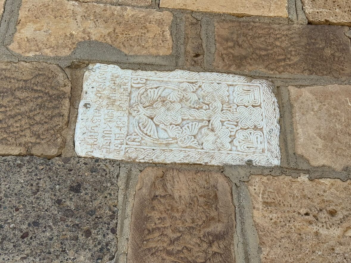
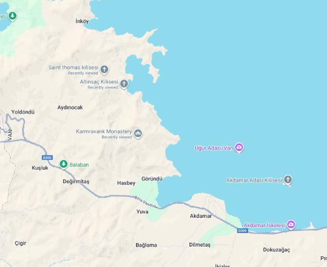
Akhtamar
Akhtamar is an island in Lake Van. It is home to a very special church.
The Cathedral of the Holy Cross on Akhtamar was built between 915 and 921 during the reign King Gagik I Artsruni, King of Vaspurakan (which existed from 908 - 1021, until the last king, Senekerim-Hovhannes Artsruni). (Note that this is a different king from Gagik I Bagratuni, king of Bagratuni. This was a period of many Armenian states, ruled by different Armenian dynasties, and Vaspurakan was one of those, along with Syunik, Artsakh, and idk what else potentially).
As a sidenote, take a look at some of the art on the walls of the Akhtamar Church depicting King Gagik I Artsruni.
It was the seat of an independent Armenian Catholicosate from the 10th until 1895. This fact is a big deal, because there have only been three Catholicosates in the history of Armenia: Etchmiadzin, Akhtamar, and later, Cilicia. Just like the Byzantine Empire had multiple Patriarchates like in Constantinople, Antioch, Alexandria, and Jerusalem, each governing a region but recognizing a shared theological framework, the Armenian Church followed a similar logic.
Today we only have one Catholicos for all Armenians, seated at Mother See of Holy Etchmiadzin. He is the supreme head of the Armenian Apostolic Church worldwide. Technically there is a second one, but he is second in rank, so it’s not the same. I’m talking about the Catholicos of the Great House of Cilicia, seated in Antelias, Lebanon.
Before I explain why, it’s important to know the following:
After the fall of the Bagratid kingdom and later the Seljuk invasions, Armenian political life shifted westward. When Armenians established the Armenian Kingdom of Cilicia, the Catholicos of All Armenians physically moved there in the 11th century.
Similarly, after the Armenian Genocide, the majority of Armenians lived outside modern Armenia. The Cilician Catholicosate became the most effective structure for Lebanon, Syria, Cyprus, Iran, etc.
If you are interested to learn more, I think this is an amazing website.
Anyway, regarding the Akhtamar church, Turkey closed the it in 2005 for restoration, and reopened it in 2007 as a museum. A cross was initially not allowed on top, caused backlash from Armenians worldwide. The cross was finally added in 2010 after international pressure.
You can read more about it on its wikipedia page.
Yukarıyongalı
I think this is top 5 most interesting parts of the entire trip for me. Yukarıyongalı is a seemingly random village on some random mountain, in the province of Muş, 130km West of Lake Van.
We accidently came across this place because one of us spotted Surb Garapet Monastery on Google Maps when searching where to go. It turns out this monastery was the most important Armenian monastery in Western Armenia before the genocide (second only to Etchmiadzin in all of Armenian lands), as well as a stronghold of the Mamikonians, and it is said to house the tombs of several Mamikonian princes, as well as the remains of John the Baptist (the person who baptisez Jesus in the Jordan River), placed there by the founder and person who brought Christianity to Armenia, Gregory the Illuminator (I recommend reading about his story, and I just learned that Hripsime and Gayane were among the first christians martyred in Armenia under King Trdat, as they escaped persecution in Rome and the churches were erected in their names as well as where they were martyred). Anyway, this monastery had a lot of significance to Armenians. Read the monastery’s Wikipedia page for more info.
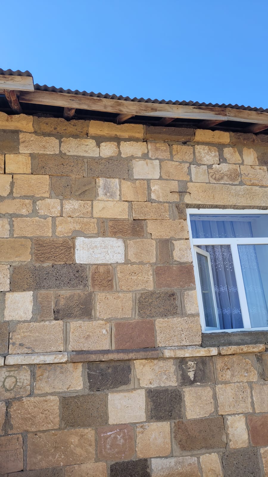
So we just followed the GPS up onto a mountain, into a village of a couple hundred people. We explored a bit, until we were approached by a man who told us he was Zaza. This was a Zaza village.
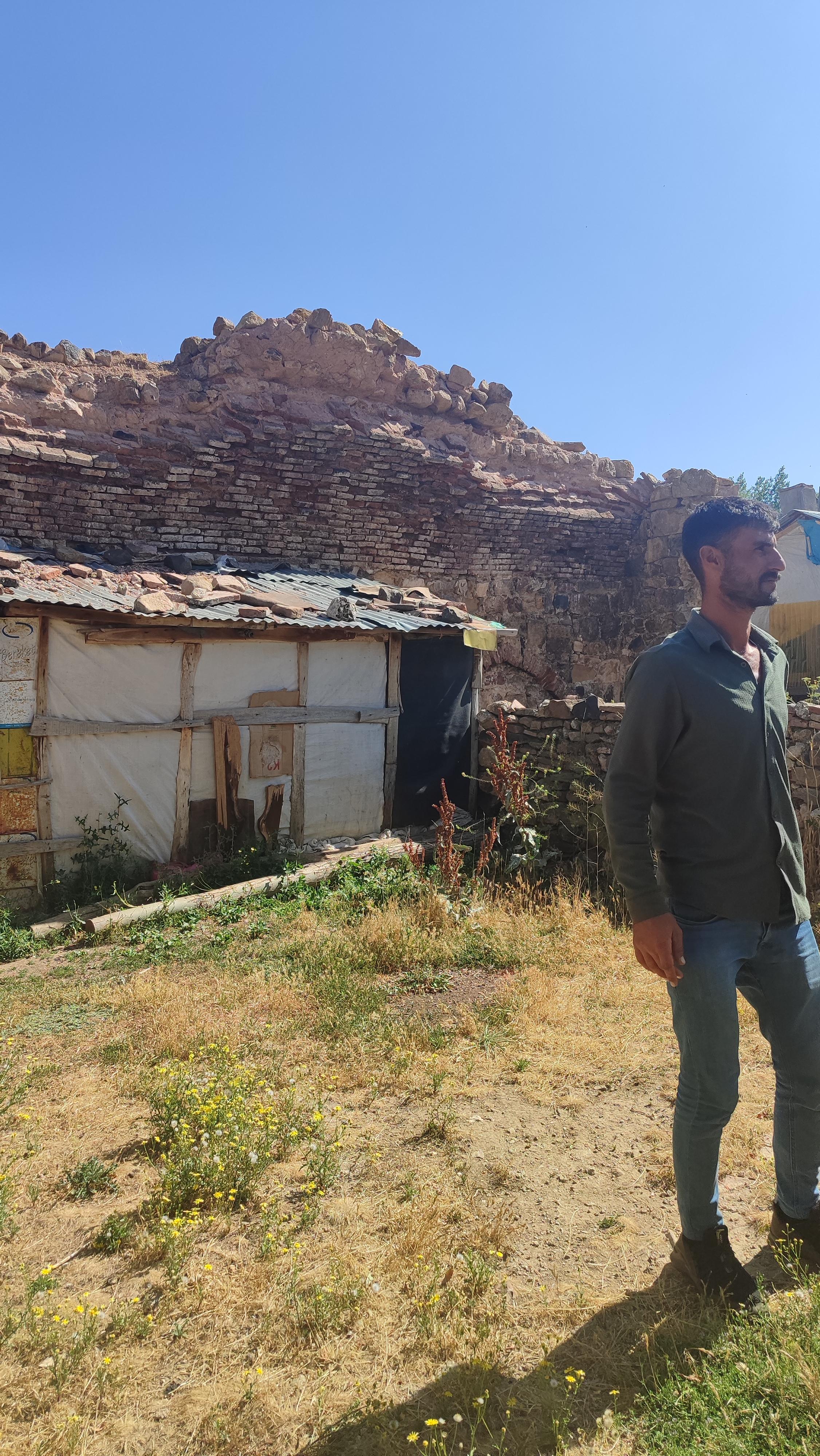
We didn’t know much about Zazas at the time, but we knew for a fact that this used to be an Armenian village. First of all because of the ruined monastery, but also because of all the stones with Armenian khachkars and inscriptions reused and embedded throughout the village.
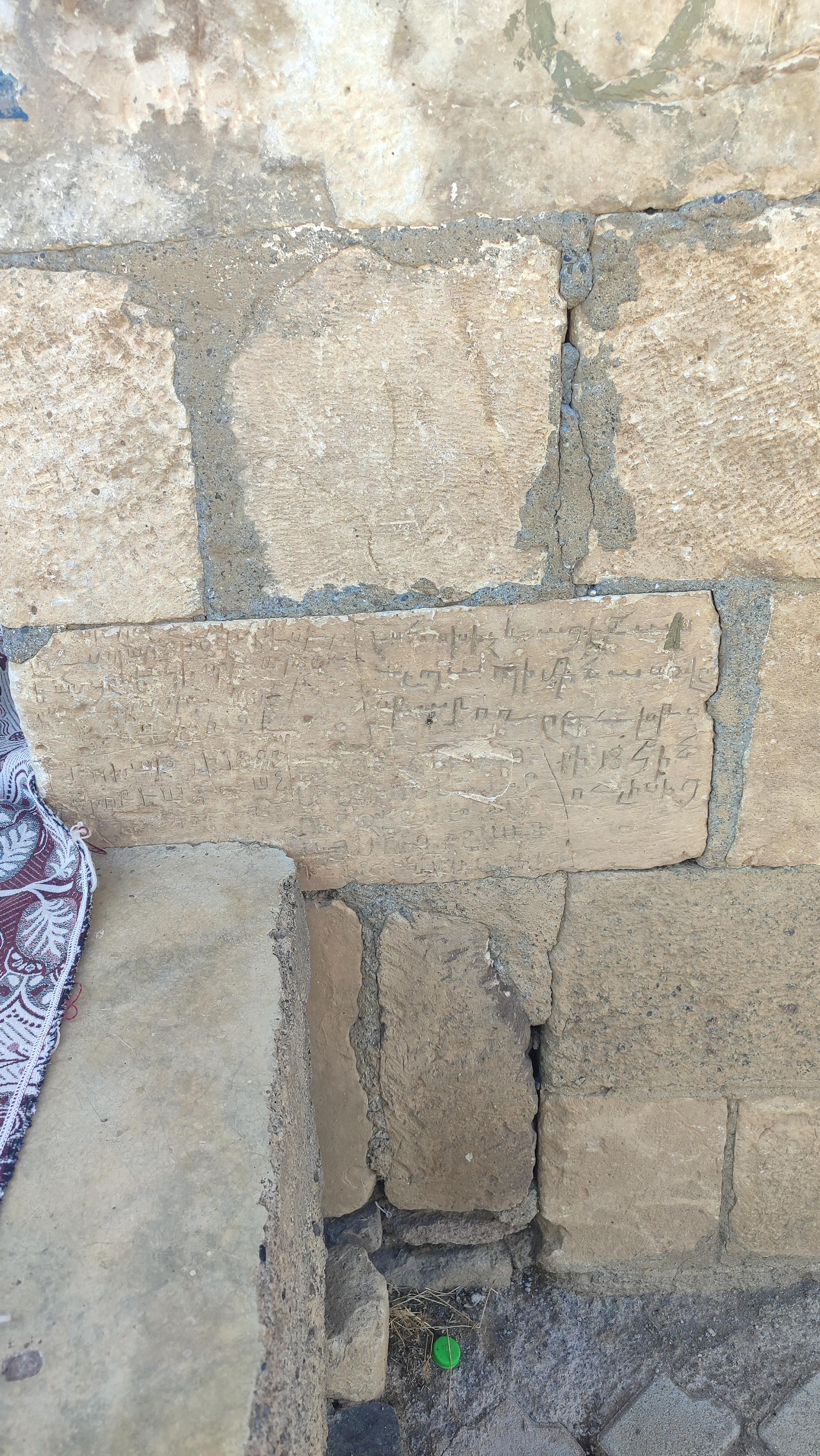
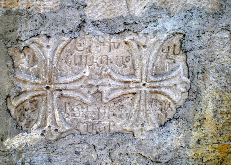
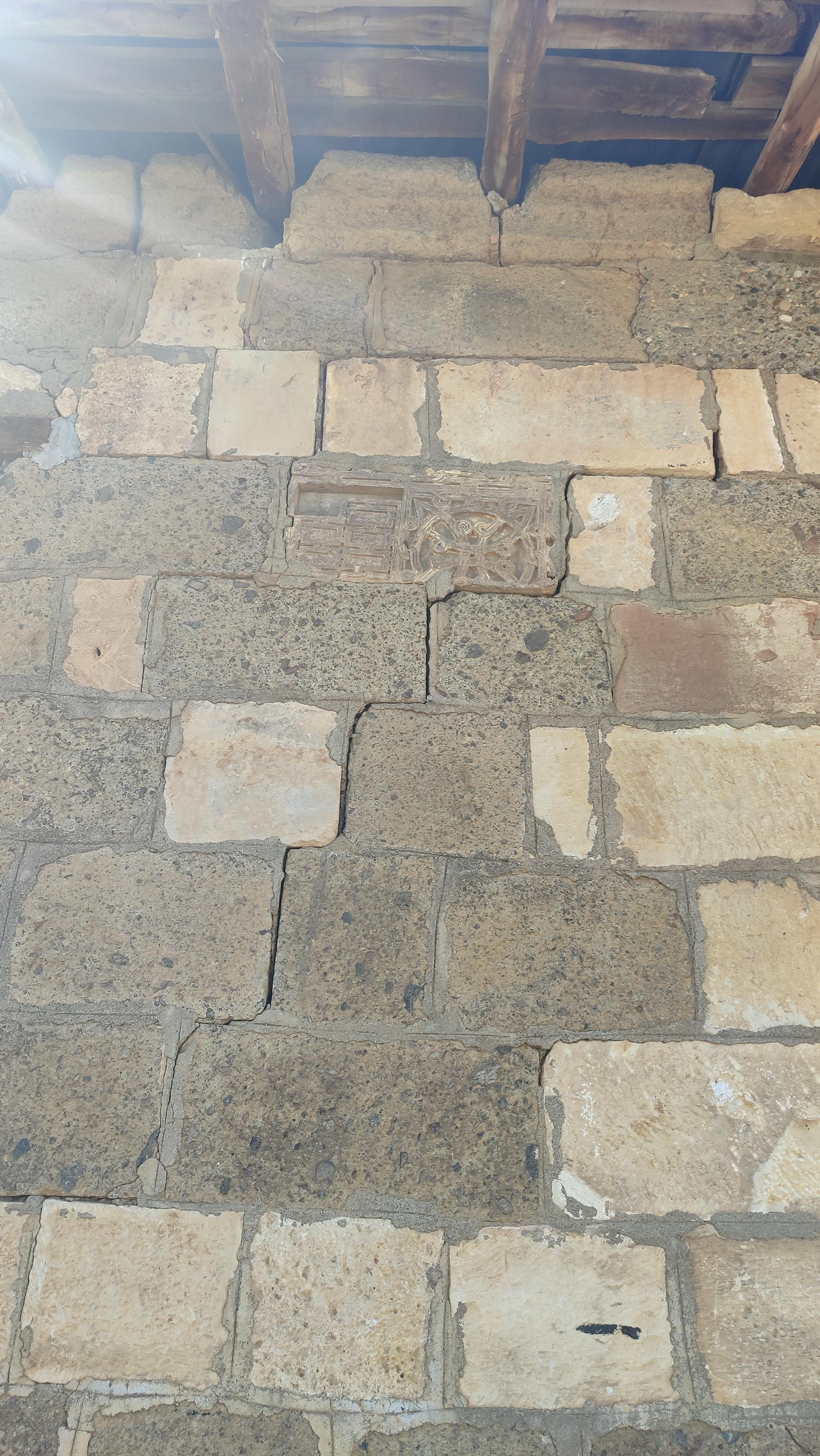
Check out the Google Maps more pictures.
But it was interesting that these people didn’t try to hide the fact that Armenians were there before. Maybe they don’t care, maybe they enjoy showing Armenians around (we tried paying our Zaza friend but he really didn’t want to accept any money for showing us around), maybe they simply see it as part of the village rather than something to explain, or maybe it’s also possible that there have been Armenian women and children absorbed into this community, and the bricklayer wanted that fact to stay in mind. Because it’s not like they were out of stones. They only used a very small portion of Armenian-inscribed stones, and they could’ve easily been hidden, and even chiseled out. But they’re just leaving it there.
There is no doubt that some Zaza tribes and individuals participated in violence during 1915. This included killings, looting, and taking over abandoned property. But just like for any group, it’s not fair to say that they all did. Zazas as a group are different from Kurds (as I’ll explain shortly), and they did not carry out a systematic extermination of Armenians in the way the Ottoman state and some Kurdish militias did. In this specific case, Wikipedia says “[this village] remained abandoned until the 1960s when Kurdish families settled on the site”.
By the way, in the Wiki article, you can ctrl+f “zaza” and will see it being mentioned in the footnotes.
Looking at maps that show the geographic spread of the Armenian Genocide, Mush clearly stands out as a major center of mass killing. Yukarıyongalı is only 25-30km away from Mush, which makes it hard to assume that the village was untouched by violence. And in fact, according to Wikipedia (which gets its source elsewhere, which I didn’t bother to look into), Armenians from nearby villages used the monastery as a refuge ground, and resisted for 2 months, but were then massacred. Allegedly 5000 Armenians were massacred there.
As a final note about our visit, we tried very lightly to push and ease into the Armenian question, but the man implied that he doesn’t know what happened to the Armenians. Now that I think about it, I’m not even sure if he had mentioned the word “Armenian”. And this was a common situation for us in Turkey, where we were very careful to ease into the the Armenian question with citizens, as we didn’t know people’s political beliefs. So if the topic came up because our motives became too obvious, I would even sometimes pretend like only one of my grandmothers is Armenian, to show I’m just curious about this topic. And especially in a remote area like Yukarıyongalı, I think it’s best to be conservative, and safe.
Who are the Zaza
If you do a population survey in Turkey today (total population of 85M), you’d get that 70-75% (60M) are Turks, 15-20% (15M) are Kurds, ~2% (1.5M) are Arabs, ~1% are Circassians, ~1% are Laz, ~0.5% are Georgians, ~0.01% are Armenians, 0.03% are Assyrians Syriacs. You could maybe see something like this. Approximately.
Now check out this interactive map of the different ethnicies in Turkey. If you’re too lazy to click off, you can just view this map:
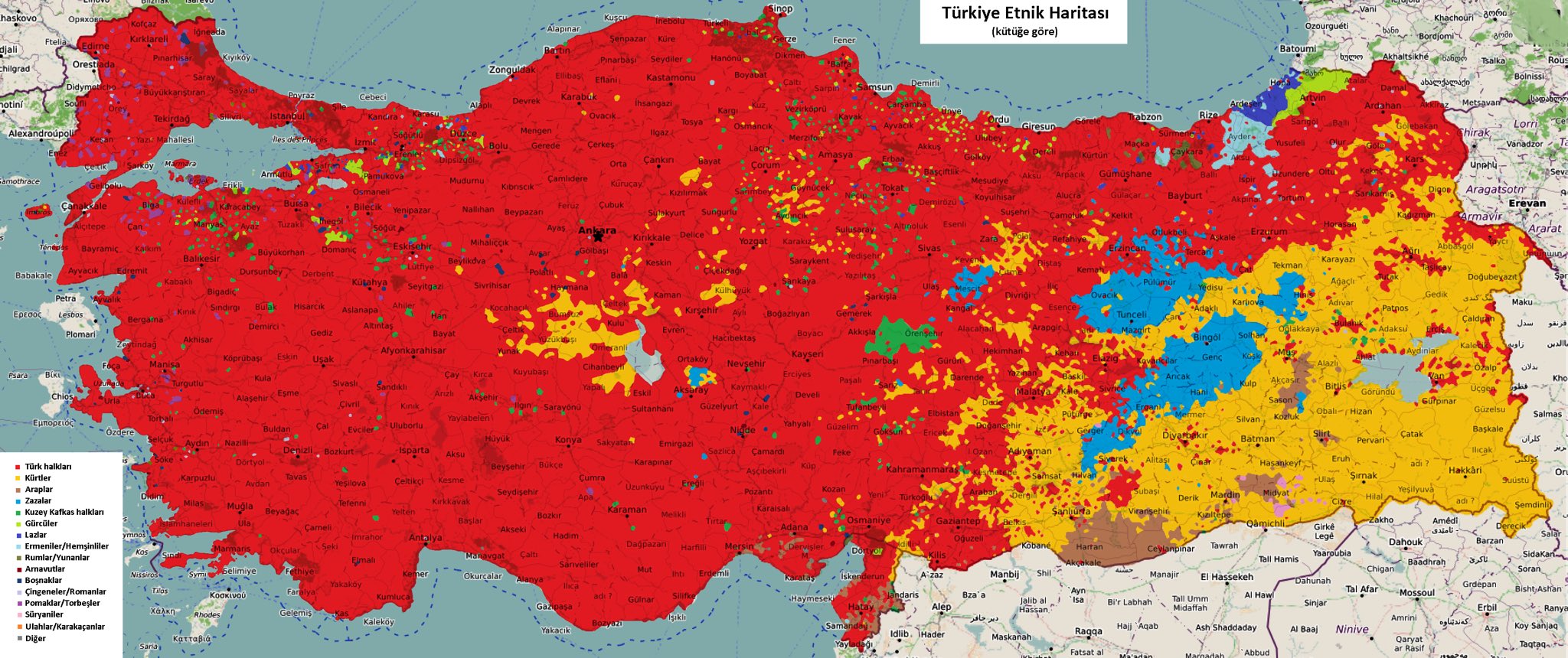
And the colors represent the following groups:
- Red: Turks
- Yellow: Kurds
- Brown: Arabs
- Light Blue: Zazas
- Dark Green: Caucasian immigrants
- Light Green: Georgians
- Purple (Dark Blue): Laz
- Cyan: Armenians (I mention Hemshen Armenians in this section)
What quickly stands out is that Zazas appear as their own category. Yet in most population surveys, Zazas are bundled together with Kurds.
They live in Tunceli (Dersim(they’ve experienced a massacre in 1938-39 under Atatürk, and the Dersim province was renamed to Tunceli)) and parts of Mush regions. And the Tunceli province is the only province in Turkey, out of the 81 provinces, where Zazas are the majority. Zazas are Alevi (religion), which is something closer to Sufism and Yazidism.
Going back to Zazas. Culturally and politically, Zazas are oftentimes grouped with Kurds due to shared geography, shared marginalization, and shared political movements. Some Zazas identify strongly as Kurdish. Others explicitly reject that label and see themselves as a distinct people. (Note on Turkish/Zaza relations)
Zazas speak Zazaki. Zazaki is a Northwestern Iranian language related to Kurdish. But Kurdish is also not just one language.
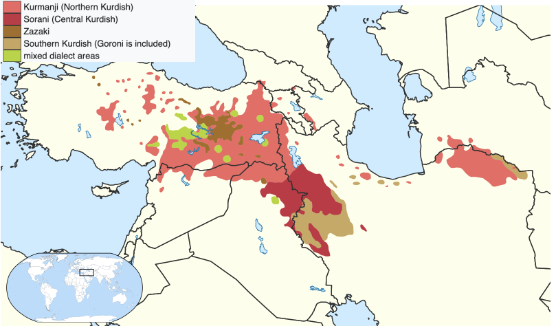
Out of the 30-35 million Kurds worldwide, 55%+ speak Kurmanji (“Northern Kurdish” as some places refer to it), 30% speak Sorani (“Central Kurdish”), and 5% speak Gorani (one of the “Southern Kurdish” dialects). This last one is the one most closely related to Zazaki. As you can see here, in the bottom right corner:
While all belong to the Northwestern Iranian language group, Zazaki and Gorani are often treated as distinct from Kurdish proper in linguistic classifications, as you can see above.
As an example, here are the languages side-by-side:
English: The weather is nice today. Kurmanji: îro hewa xweş e. Sorani: ئەمڕۆ هەوا خۆشە. (pronounced as: em-rô ha-wâ kho-sha) Zazaki: ewro hewa xoş e. Gorani: ewro hawâ xoş e.
Mutual intelligibility between Zazaki and Gorani is the highest among all pairings discussed here. Other pairs generally require some exposure (which they do get because media and schooling is often in Kurmanji or Sorani, as they have more speakers) and learning, though the learning curve is not very steep.
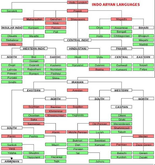
And here is the bigger picture, zooming out of the Indo-Iranian tree, because this is a subgroup of the Indo-European family:
Fun fact about the Kurdish language: From 1921 to 1928, Kurmanji Kurdish spoken by Kurdish communities (mostly Yazidi Kurds) inside Soviet Armenia was written with a version of the Armenian alphabet in the Armenian SSR. Kurdish newspapers, political pamphlets, children’s books. Look at how they modified Armenian letters to make their own sounds. The Soviets did this for three main reasons:
- The Armenian infrastructure (schools, press, etc.) already existed, so it was practical.
- The USSR was secularizing everyone. And Islam is a very strong religion, and Arabic is associated with Islam. So the Soviets wanted to move the Kurdish literacy away from Arabic script.
- Many Kurds living in the area were already familiar with Armenian script through everyday life surrounded by Armenians, Armenian businesses, administrative duties, etc.
Then, between 1928–1940, Kurdish was written in Latin alphabet, and after 1940, it was forced into Cyrillic. Today from my understanding they went back to latin letters.
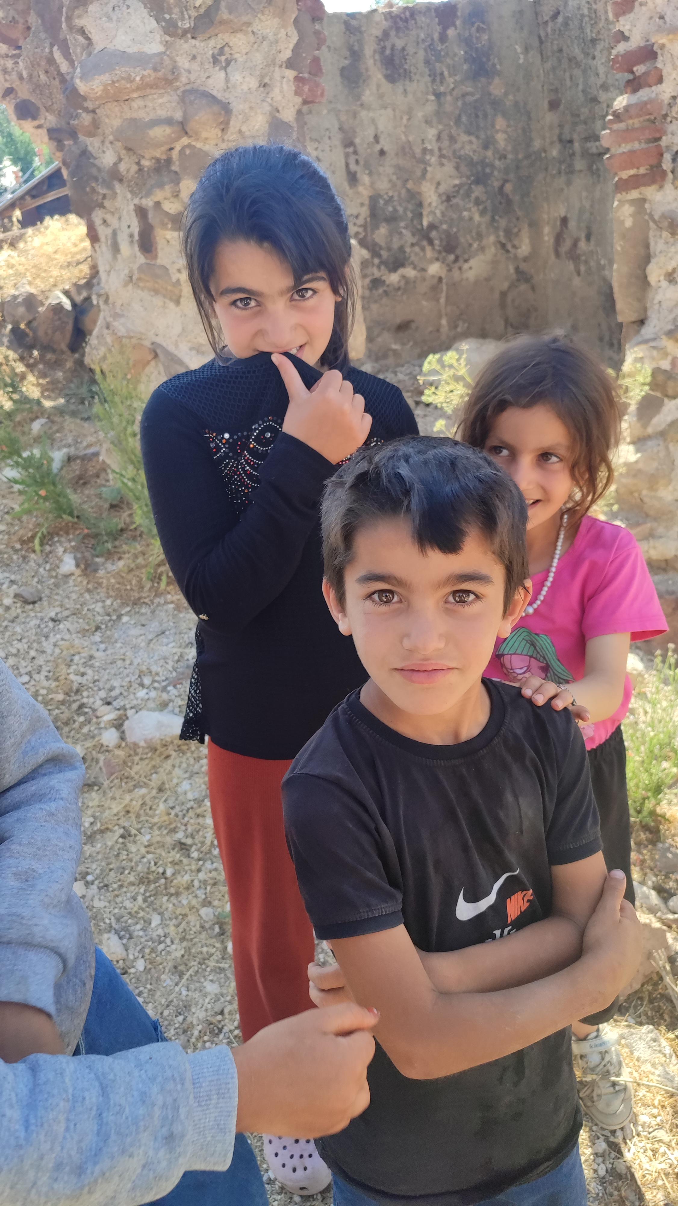
The women and children of Yukarıyongalı:
Just a note to my future self in case I read this. I came across these and would read it if I had the time. Read these if interested:
- [https://en.wikipedia.org/wiki/Western_Armenia]
- [https://en.wikipedia.org/wiki/Turkish_invasion_of_Armenia]
- [https://en.wikipedia.org/wiki/Soviet_invasion_of_Armenia]
Cappadocia
I don’t expect many people to know this, but Cappadocia was once inhabited by Armenians. I learned this during the trip itself when I started to zoom into Cappadocia on Google Maps while we were driving there, and started to notice churches. These were not Armenian churches, but it’s still a hint. So I started to dig deeper.
First, the basic thing about Cappadocia that makes the rest of this story possible:
The region is made of soft volcanic tuff (the same tuff that Armenians like to build their buildings with). Volcanoes in the region laid down layers of ash and rock, which got compressed over time. Then erosion (wind, water and gravity) carved it into those shapes people call fairy chimneys. The important point is the tuff is soft enough to carve with hand tools, but stable enough to hold shape if you carve it properly. That means you can carve houses, storage rooms, churches, monasteries, tunnels, and entire underground complexes.
So what did this region go through, historically?
Although smaller farming communities lived there before, the earliest known major civilization in the region were the Hittites (c. 1700–1200 BCE).
You could see in this video, if you fastforward to approximately the year 1700BC, that the Hittite Empire, even though we’ve never heard of it, was one of the largest of its time.
Then the Hittite Empire fell, and the land continued to be inhabited by local communities.
Then the Persian Achaemenid Empire (c. 550 to 330 BCE) arrived and gobbled up that area and the people living there. It turns out that this area was renowned for its horse breeding and supplying the Persian empire with its horses. Because off this, this area was given the name Katpatuka, which in ancient Persian mean “land of beautiful horses”. It was just another satrapy (“province”) which they arbitrarily drew lines on a map in order to administer for tax and organization purposes. Katpatuka also had local elites who were under imperial oversight.
Then the Greeks adapted it into Kappadokia, and Romans into Cappadocia. So the name that reaches us is filtered through Persian administration and Greek writing.
As per Wikipedia, “[in] 330 BC, amidst a military campaign that began in 336 BC, the Achaemenid Empire was conquered in its entirety by Alexander the Great, who annexed it to his Macedonian Empire. Upon Alexander’s death, which sparked the beginning of the Hellenistic period in 323 BC, the majority of the former Achaemenid Empire’s territories came under the rule of the Seleucid Empire and the Ptolemaic Kingdom.”
But the satrapy of Katpatuka (which was by then known as Καππαδοκίας (Kappadokia) in Greek, or Cappadocia as the Romans would write it) quickly gained independence and became the Kingdom of Cappadocia (330 BCE to 17 CE). For many of those years, it wasn’t an independent kingdom though, but often a vassal or client state, either of the Seleucid Empire, or later the Roman Republic, and then the Roman Empire (starting in 27BC).
In 17 CE, Rome annexed Cappadocia and turned it into the province of Cappadocia.
From then on, it was no longer a kingdom, but it remained a clearly defined region in Roman and Byzantine maps for centuries. And after the Romans, it fell into the hands of other smaller kingdoms, until the Seljuks and Ottomans took it to themselves.
Where Armenians Fit Into Cappadocia
And that is a summary of the history of Cappadocia as a region. Now the question is where Armenians fit into this picture, because if you are walking through Cappadocia today, the number of churches is striking. There are far more churches carved into the rock here than in most parts of Turkey. That alone tells you that this was a heavily Christian region for some time.
This is where we have to start looking into the underground world of Cappadocia. While the Hittites were probably carving early underground structures for food storage and hiding valuables, it is possible that at the end of that empire, and the post-Hittite fragmented communities would start expanding the underground spaces to hide from raids and attacks (which became more common now that there is no central government), but it was very short term and at a small scale. No giant, permanent, underground cities yet. Just “emergency cities” used to evade danger.
Same thing during the Persian and Hellenistic periods (c. 550 BC to 200 CE).
At some point though, Christianity spreads to the people of that region, and since the Roman Empire only legalized Christianity under Emperor Constantine in 313, the early Christians expanded the underground space to build underground chapels and hidden worship spaces. So here we see the start of these spaces being used as organized community shelters, and being used for longer periods of time, so they also had to include ventilation shafts and even wells. Once Christianity was legalized, the community started carving churches outside, making them visible, which are some of the ones we can visit today in that region (such as the Tokalı Kilise, or Buckle Church, in Göreme).
But the underground spaces which were already carved out turned out especially useful with the approach of the Muslims (think c. 650 to 950). The Arab Caliphates of Rashidun, Umayyad, and Abbasid armies raided Anatolia repeatedly, and Cappadocia happened to be at the forefront of that sometimes. And this is where the huge underground cities like Derinkuyu and Kaymaklı grew to hold thousands of people with a dozen levels of layers going down. Archaeologists estimate that Derinkuyu (the deepest and most complex one) could shelter about 15’000 to 20’000 people, plus animals and food stores. And there are dozens of such (but smaller) underground cities in Cappadocia.
And it turns out that in 1021, the last king of Vaspurakan (the kingdom centered around lake Van, 908 - 1021), the son of King Gagik I Artsruni (who I mentioned earlier in the Akhtamar section), Senekerim-Hovhannes Artsruni, handed his kingdom over to the Byzantine Empire in exchange for lands further west, including in Cappadocia. This decision came under increasing pressure from Seljuk advancements from the east and the weakening ability of Armenian kingdoms to defend their borders independently.
And this situation gives us a glimpse into how empires behave, which you can read more about if interested in the note. (Note 4)
Anyway, in 1071 the Battle of Manzikert happens. The Seljuks defeat the Byzantines, and Byzantine control of Anatolia begins to weaken. From this point on, there was no more “frontier chaos”, no more unpredictability. Random raids were replaced with (relatively) stable taxation, and so the underground systems slowly stopped being cared for and maintained, until, a few generations later, they just became abandoned cavities.
This battle is a popular and important one, because regions that had felt like the interior of the empire suddenly start to feel exposed. Roads become unsafe. Anatolia is no longer a stable area.
But long before 1071, the Byzantine Empire had been deliberately resettling Armenians into Cilicia and nearby regions. From the tenth century onward, Armenian soldiers, nobles, and their families were moved into southern Anatolia as part of Byzantine military and administrative policy. The empire used Armenians to garrison frontier zones, guard mountain passes, and stabilize regions that were difficult to control directly. This meant that by the early eleventh century, Armenian communities already existed in Cilicia, with churches, estates, and local networks.
And with the Battle of Manzikert, there was one last push of Armenians toward Cilicia (I have to mention it wasn’t a one-time event, but rather a multi-decade transition). It looked attractive not only because Armenian communities were already established there, but also because it offered access to the Mediterranean (to enable trade and connection), protection from the Seljuks through the Taurus Mountains, and fertile land.
Once enough manpower has been gathered, Armenian leaders in Cilicia begin to turn this demographic and military presence into political control. They seize fortresses and take control of mountain passes. Eventually, a new Armenia, the Armenian Kingdom of Cilicia (1198 - 1375), was formed.
So, to conclude, although Cappadocia was never an Armenian kingdom, and it was never a core Armenian homeland, it became a place of settlement, refuge, and transition for them. Just as any Christian group would’ve found solace in those lands and underground cities.
A Potential Future Trip
Let’s look at this map again.
If my goal is to follow “Armenianess”, well then it’s quite obvious that the southern portion is where I’d go next time. Going all to way to Adana, visiting Batman, Diyarbakır (Tigranakert), Mardin, Şanlıurfa (Urfa), Kahramanmaraş (Marash), Gaziantep and much more (which I’d have to research about) along the way.
Actually, this is such an amazing website which lists all the Armenian sites in Turkey (and Georgia and Iran and the ME too) which I only found out while researching for this article.
And if you do go in this direction, an absolute must is the village of Vakıflı, as well as the mountain nearby. The population is 100-150, and they are mostly ethnically Armenian, and they speak Western Armenian (and Turkish). And if you look close by on the map, you will see that Mount Musa is nearby. The same mountain on which 4000 Armenians from 7 villages took arms and resisted the Ottomans for 53 days until they were rescued by the French. This was during the Armenian Genocide by the way, and there’s a famous book that talks about it called The Forty Days of Musa Dagh by Franz Werfel.
Anyway, those rescued Armenians were taken to a refugee camp in Port Said, Egypt. After WW1, as part of the Treaty of Sèvres of 1920, that area which is today Turkey’s Hatay Province, was part of the French-administered Syrian territory. And since it was now controlled by the French, those Armenian refugees went back to their homes around Mount Musa (not only, since it was estimated that 11% of Hatay’s 220’000 population was Armenian, and ~40% were Turks). Mustafa Kemal Atatürk claimed that Hatay was Turkish and should be part of the new Republic of Turkey, and the French wanted to secure Turkey’s neutrality before WW2, allowed the creation of a transitional country called Hatay State, which existed between between September 1938 and June 1939. Anyway, Hatay State was annexed by Turkey, and so since 1939 it’s part of Turkey. And once that happened, most Armenians left (especially to Anjar, Lebanon), and only some families in Vakıflı stayed. And today’s 100-150 inhabitants of Vakıflı are the descendents of those people who went back and never left.
Another potentially interesting trip would include traveling closer to the northern coastline of Turkey. The Hemshin Muslims in Rize and Artvin are an interesting group to learn about as well. They were Armenians who converted to Islam during the Ottoman rule. The name comes from the region of Hemshin, or Hemşin, near Rize. According to this source, there was the Armenian price Hamam in the 8th century who led a group of Armenians up north from the Arab invasions in Vaspurakan. And he named city Hamamshen, meaning “Hamam’s hamlet” in Armenian. So that’s where today’s Hemşin name comes from, and they even speak an Armenian dialiect called Homshetsi, but it’s complicated because one language was turkified, and then some eastern part speak something closer to Armenian. Worth exploring if interested.
[January 28, 2026 Update] Taken directly from this article (which I recommend reading in its entirety):
“Until recently, most Hamshen people had a strong nationalistic—even racist—allegiance to Turkey. In conversation with a Hamshen woman, I was amazed to hear the following: “Yes Hay chem. Yes Turk em” (“I am not Armenian. I am a Turk.”)—in Armenian!”
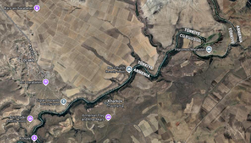
I think if someone likes to hike, and has time, it would be cool to go from the designated Ani archeological site, to the Red Church and Horomos. Kizkale church (Kızkalesi) seems also very interesting, just I haven’t found it on Google Maps, not sure where it is, but I’m sure if you dig deeper you will find it. Because this website talks about it, and these guys walk to it.
I’d recommend doing what these guys did, and that’s go to check out this church on the way to Van. Just be safe out there when hiking mountains, always be prepared for snakes or wild animals.
Another note on the way to Van is, I didn’t really appreciate it in the moment, but the view of mount Ararat is the best from the city of Iğdır. Because you think that it’ll get better, and you want to get behind Sis and Masis, but the behind is hidden by other mountains. So take a stop at/near Iğdır to look at Masis (the bigger of the two mountains).
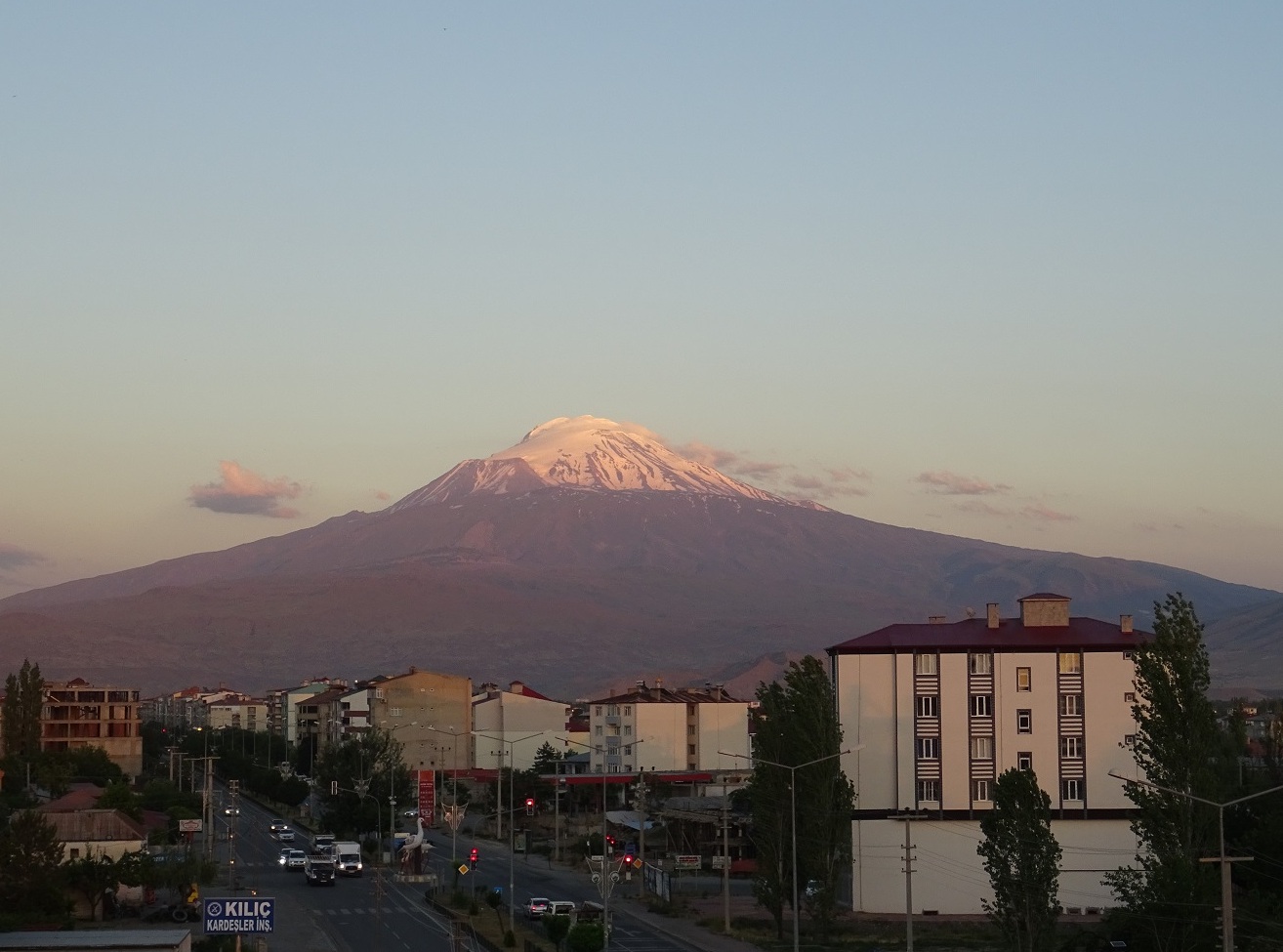 Source: [https://ku.m.wikipedia.org/wiki/W%C3%AAne:I%C4%9Fd%C4%B1r_ve_A%C4%9Fr%C4%B1_Da%C4%9F%C4%B1.jpg]
When visiting Akhtamar, we had these churches on our list but I guess we spent too much time in Akhtamar, since we spontaneously decided to swim there after seeing others doing so (highly recommend, if weather insists).
You feel extremely greasy from the lake, and at first we thought it’s because they dump some industrial waste into the water or something, but turns out that that is the natural chemical composition of that lake. It’s what is known as a soda lake, which is any lake with a pH of between 9 and 12. It’s just rich in particular salts which makes the water highly alkaline (Lake Van has a pH of 9.7), and when our skins touches these salts, and leaves a soapy feeling. As long as you don’t have any cuts on your skin, and you shower afterwards, there is no problem.
For fun I checked what would happen if you were to drink the water from Lake Van. If you take a few sips, your stomach acid (pH ~ 1.5-3.5) would immediately neutralize it.
Finally, I would recommend to explore all the Byzantine churches in Cappadocia, underground and above ground (to be honest I didn’t look into what’s possible, so can’t recommend anything in specific).
1
Before going far into history, let’s briefly mention a modern example. Since these things happen in stages, we can see some of the early stages of the cycle.
President Ilham Aliyev and state media regularly refer to Armenian cities and regions using Azerbaijani or Turkic names, even when those places are internationally recognized as part of Armenia, such as Lake Sevan (which they call Lake Goycha), and Yerevan (which they call Irevan). This is done under the pretense that Armenians live on historically Azerbaijani land. And unfortunately without international law, disputes like these are not settled by history or truth, but by strength.
Okay, back to what I wanted to talk about. Names of cities. An obvious example to begin with is Istanbul, which used to be Constantinople, the City of (Roman Emperor) Constantine.
In 285 CE, the Roman Empire was divided in two for easier rule: one emperor in the East and one in the West. The Eastern Roman Empire became what we later call the Byzantine Empire, with Constantinople as its capital (named after Emperor Constantine in 330 CE). The Western Roman Empire collapsed in 476 CE, while the Eastern half survived another thousand years until it was captured by the Ottomans in 1453.
Greeks have always referred to Constantinople as “the city”, and they have continued doing so when the Turks arrived. Over time, the Turks have heard countless times the phrase “εἰς τὴν Πόλιν” (“is tin pólin”) which means “to the city” in Ancient Greek. In turkish pronunciation, that became Istanbul. By the nineteenth century, “Istanbul” was already widely used among Turks, while “Constantinople” remained in foreign and official documents.
After the fall of the Ottoman Empire in 1922, the new leader, Mustafa Kemal Atatürk, carried out a wide set of modernization reforms. One of them was language reform. The Arabic script was abandoned and a Latin alphabet was introduced in 1928. Alongside this came the standardization of place names.
In 1930 the Turkish government formally asked the international community to use “Istanbul” instead of “Constantinople.” This was done through an official notice to foreign governments, embassies, and international postal services.
Okay, so that is the story of Istanbul. We could say this was a fairly natural change of names. The word Istanbul grew out of everyday speech, and Turks had already been using it for centuries. The government’s request in 1930 only made the rest of the world follow suit.
But not all name changes in Turkey happened so naturally. Under Sultan Abdul Hamid II in 1880, even the word “Armenia” was banned from schools, newspapers, and official records. The first name changes started when, in 1916, the minister of war, Enver Pasha, ordered that towns, villages, rivers, and mountains with Armenian, Greek, or Bulgarian names be replaced with Turkish ones.
After the Turkish Republic was founded in 1923, Mustafa Kemal Atatürk’s reforms continued the process. He even banned imported maps and non-Turkish street names in Istanbul were changed by 1927. In 1952, the Special Commission for Name Change was created and went on to change tens of thousands of names across the country. Mountains, rivers, streets, monuments, quarters and neighborhoods. Not to mention villages, towns and cities. And it’s not just Armenian names of course. That geographic location is full of history, contributed by countless ethnic groups, including other muslim groups. It is agreed upon that thousands of Armenian, Greek, Kurdish, Arabic, Georgian, and Assyrian place names were officially changed over time.
Kurds and other Muslim minorities were mostly exempt from name changes during the Ottoman Empire because the state presented itself as an Islamic caliphate (which just means that its led by a caliph, the successor of the Prophet Muhammad and the leader of all Muslims). But after the Ottoman Empire collapsed, and after Armenians and Greeks were eliminated, the pressure turned on them as well. During the genocide, many Kurdish tribes were promised land and property in return for helping in the massacres and deportations. Some benefited for a time, but once the new, secular and modern Turkish Republic was born, they too faced assimilation.
Here are some examples of the name changes:
- The Armenian island of Aghtamar (about the legend of Princess Tamar) became Akdamar (white vein).
- Dikranagert (named after king Tigran), in 1937, was made into “Diyarbakır” (“land of copper” in Turkish). By the way, this city was known as “Amed” by Kurds and Assyrians. There is also claim that it used to be called “Diyar Bakr”, meaning “land of the Bakr tribe,” used by Arabs from early medieval times. So Diyarbakır could just be its reinterpretation of that (nonetheless, they gave it a new meaning).
- Karin became Erzurum, which comes from Arabic Arz al-Rum (land of the Romans).
- Sebastia became Sivas.
- Kharpert became Harput, and the new city of Elazığ was built next to it.
- Erznka became Erzincan.
- What Armenians know as Kesaria, which comes from the Roman “Caesarea”, is today known as Kayseri.
- Mount Masis, also known as Ararat, became Ağrı.
- The ancient city known to Greeks as Smyrna (destroyed in 1922) was renamed Izmir (again, foreign governments were asked to adopt this new Turkish name).
- Georgian town of Vitz’e renamed to Fındıklı (“place with hazelnuts” in Turkish).
To reinforce this knowledge, you can see some of these here:
And here:
So as you can see, sometimes they tried to find similar words that meant something in Turkish, and make it seem like it was a gradual and natural change in language, adopted by the inhabitants. But in reality, it’s been ordered one day to change. They tweak the sound and spelling into a Turkish form, keeping it recognizable and Turkifying it at the same time. The old identity gets quietly phased out, and over time, younger generations grow up thinking the Turkish form was the real name all along.
By the way, if you scroll down to the various maps on this website or the corresponding wikipedia page, you will see which ethnicities lived where in Turkey. I highly encourage a quick look at it.
Now what about a place like Van? Van stayed Van, probably because Van was so ancient and tied to the ancient kingdom of Urartu, which Turks don’t even believe are related to modern Armenians. And something like Nakhichevan? Nakhijevan means “first resting place” in Armenian, as it is thought that after landing on Mount Ararat, Noah first settled in the Nakhijevan area. Nakhichevan is one of the oldest continuously inhabited places in the region, mentioned by Greek, Persian, Armenian, and Arab historians for over two thousand years. So changing it outright would be a bit awkward, and what the Turks/Azeris say instead is that it’s of ancient Turkic origin (Naxçıvan), rather than Armenian. And so they can say that, destroy the tens of thousands of Armenian artifacts, and claim continuity of their rule over that land. Unfortunately for them, this part of history is recent enough that it is well documented from outside sources.
One last point I’ll mention is that many of these places were called differently by the various minorities present in the region, such as Dikranagert/Amed. But the point is that these names were passed down through generations of natives and bear thousands of years of history, while the new name (Diyarbakir) was made up by a committee in an office to obscure history and attempt to cover up a century of ethnic cleansing.
Renaming a place is the last step of a cycle that’s happening even today. Azerbaijan recently captured the Armenian territory of Artsakh, and they will now make sure that everybody follows suit with their names. Google Maps used to have Stepanakert, capital of Artsakh, but now it only has Khankendi.
Destroy, erase, rename, repeat.
2
Even in a clearly Armenian place like Ani, look at the signs they have there:
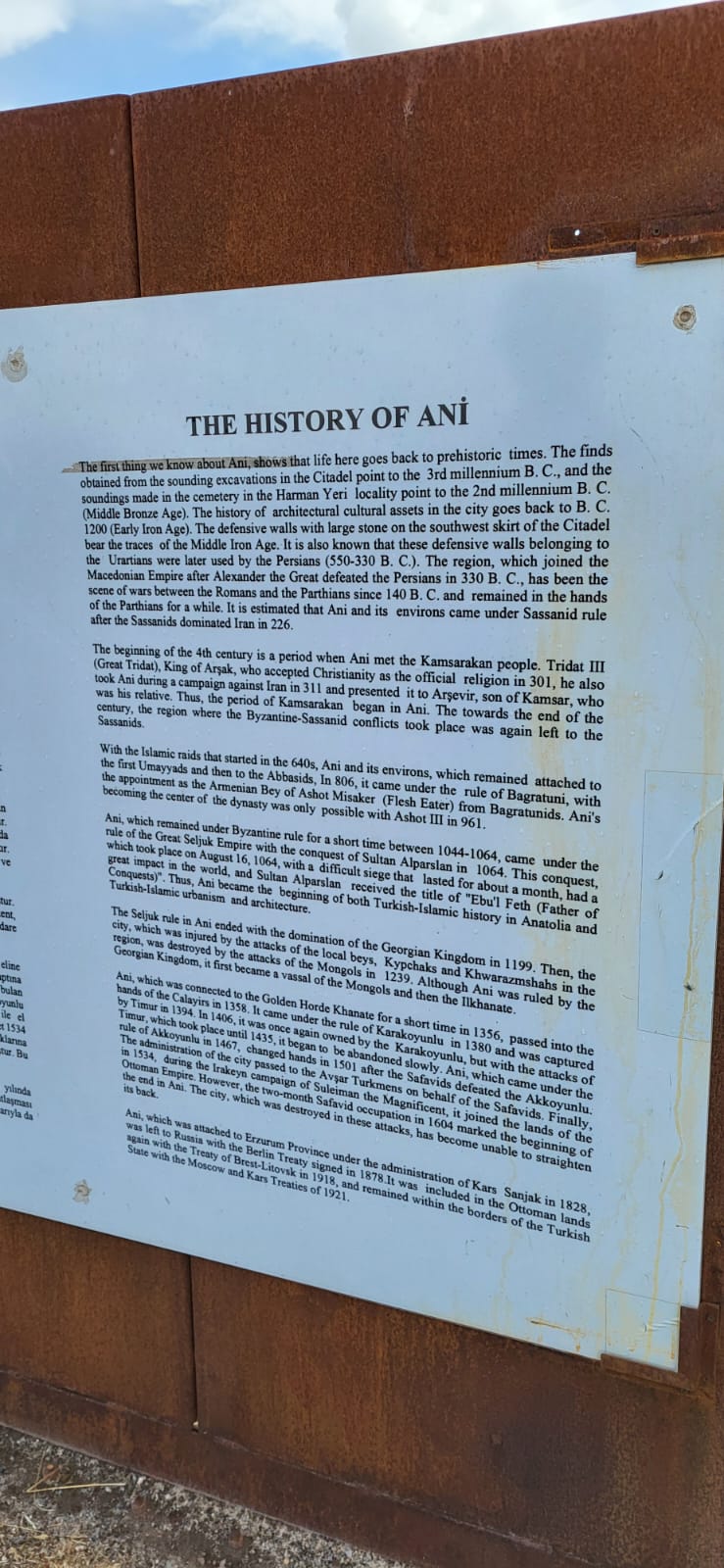
To say a territory is under some empire is one thing, but to mention the people who lived there is another. Being an Armenian living around that area at the time, you could one day be under the Romans, another day under the Persians, another day under the Muslim caliphate, and another under the Armenian Kingdom. Watch it happen here. But your day to day as a citizen doesn’t change that much. The empires didn’t micromanage each of their territories. So to say “this land has belonged to all these kingdoms” strips a layer of truth. A constant is removed. And that constant are the Armenian people who lived there. For millennia. That entire region is called the Armenian Highlands for a reason.
The first sign, second paragraph. It says “Kamsarakan people”. Google who those are. Reading this you’d think the people in question in the second paragraph are different from the people in the third paragraph. Says “Tridat III (Great Tridat), King of Arşak, […]”. The ‘ş’ makes things seem like it’s some Turkish empire. This is supposed to be the English translation of their Turkish text on the left (not visible in the photograph). We don’t have the letter ‘ş’ in English. Did they ask an intern to work on this? I don’t understand. But anyway, beyond that, even if they wrote “King of Arshak”, that’s not a real title. It’s Trdat III of the Arshakuni (Arsacid) dynasty. Not “Tridat”, not “Arşak”. Then they say “Arşavir”, who is actually “Arshavir II Kamsarakan” from my understanding. I don’t want to go too much into it. But in general,
An Armenian king did not rule directly everywhere, but rather relied on “nakharars” (which back then was used for “hereditary nobles”) to govern regions. An exemplary structure would be having the King (Arshakuni), and regional noble families (Kamsarakan, Mamikonian, Bagratuni, etc.). Each noble family ruled its lands hereditarily. And if a king weakened or disappeared, nakharars became somewhat independent (I didn’t look into the details). And that’s exactly what happened in 428, when the Arshakuni kingdom collapsed, and Armenia had no king for 450 years. So during that time, the nakharar houses competed, adapted, and survived. And the Bagratunis steadily accumulated power, until they became the dominant “Armenian house”, and were titled the kings of Armenia in 885, and found the Bagratuni Kingdom of Armenia (the medieval Kingdom or Armenia), which lasted until 1045.
Back to the sign. The biggest disrespect in my opinion is in the third paragraph, where they write “Armenian Bey of Ashot Misaker (Flesh Eather)”. Usually people lie when it comes to actions, like “person X did this” when person X didn’t do it. But these guys manage to lie on a name… twice in that little excerpt. I don’t know how. “Bey” is a Turkic title used centuries later by the Seljuks and Ottomans. It was not used in 9th-10th-century Armenia. I don’t know how they could justify writing this. How could this historically rich site, being a UNESCO World Heritage Site, be projecting a later Turkic title backward in time. On Armenians, who never had this title. Anyway. Actually I just realized why they finally used the word “Armenian”. Because they never do. It’s the only time I see it… It’s because they wanted to emphasize the fact that this “Bey of Ashot” is a “flesh eater”, implying he was brutal and would eat his enemies (and maybe his own peoples!!!) flesh. Anyway, while in English we may use “meat” to imply “human flesh”, I don’t think it’s the same in Armenian. “Mis” in armenian is specifically the meat of an animal. If he were cannibalistic, he’d be named otherwise. But he was named Misaker because he would refuse to refrain from eating meat during Lent. That’s the explanation I found online. And on that note, it’s funny how they omitted that Ashot III (who they mention at the end of the third paragraph) is also known as Ashot the Merciful. He was the king (953–977) who greatly expanded Ani, led its massive growth, turned it into a Silk Road city, turned it into the “City of 1001 Churches”, and began the golden age of Armenia.
What’s the point of trying to erase the history of a place? What’s the point of making it seem like Armenian are bad? Why not just talk about history in a balanced manner? The land is theres today anyway.
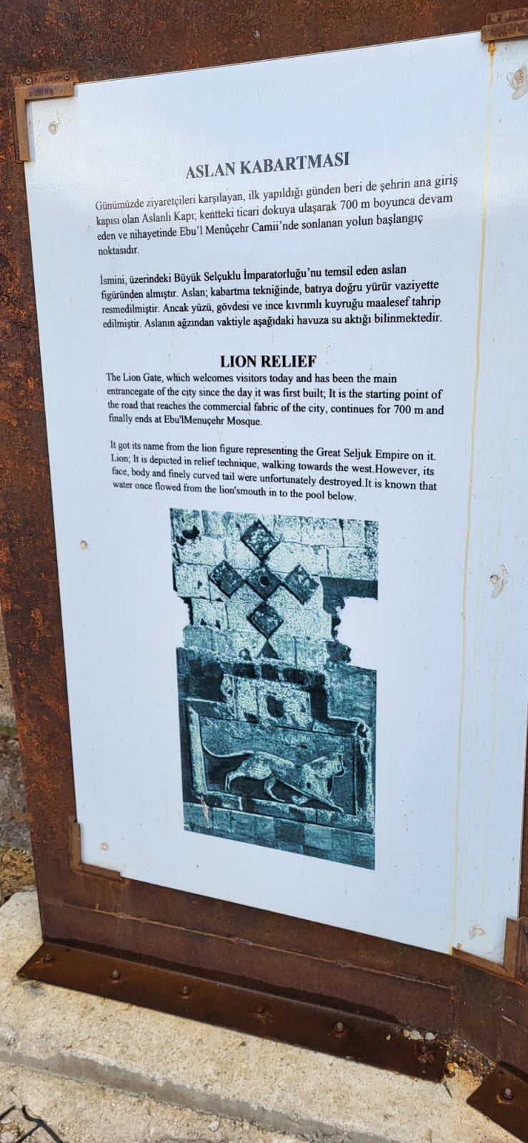
Anyway, regarding the second picture, Google “Great Seljuk Empire symbol” or “flag”. And then Google “Bagratuni kingdom flag”. Simple.
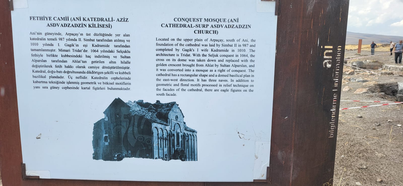
And regarding the third picture, we see “Simbat”, “Gagik”, “Tridat”. First of all… it’s Smbat, and it’s Trdat. Second, this was the main cathedral of Ani, the capital of the Kingdom of Armenia. The seat of the Armenian Catholicos at Ani. This is the equivalent of Azerbaijan capturing Armenia today, replacing the cross on top of the Etchmiadzin cathedral with a crescent, and writing “Liberation Mosque (Eçmiədzin)”. (Liberation of course because they’d think they liberated the land from the pesky Armenians).
3
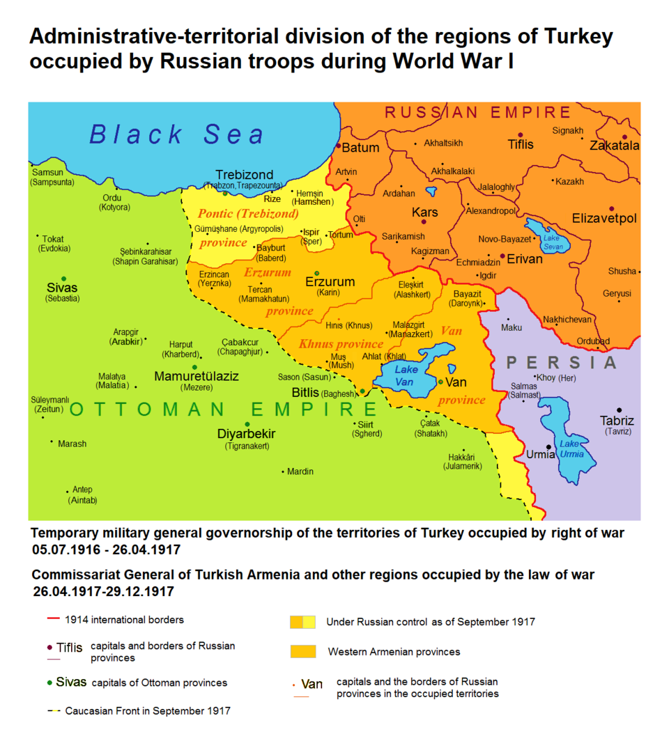
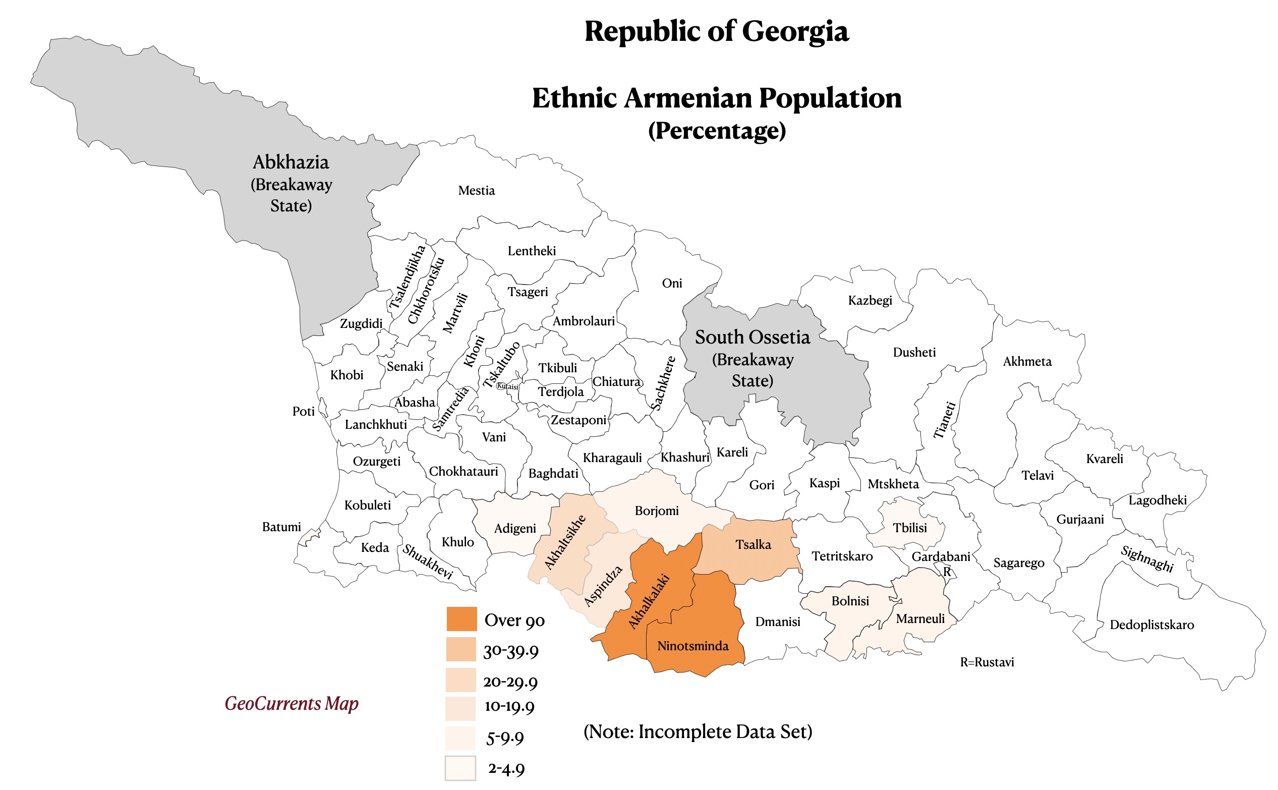
The region called Javakheti, in Georgia, is majority Armenian (50%+). Towns like Akhalkalaki and Ninotsminda are 95%+ Armenian.
That region has been historically Armenian for centuries. It was part of many Armenian kingdoms (I’m not good at this but it can be traced back to the Urartians from the 9th–6th century BCE. And if you don’t consider the Urartians as Armenians, then there’s the Orontid Dynasty, which is considered the first Armenian dynasty, from the 6th–2nd century BCE). So ever since then, there were Armenians living in those lands; through Mongol, Persian, Ottoman, and finally Russian rule.
Especially after the 1828 Russo-Turkish War, when the Russians took the territory from the Ottomans, many Armenians fled the Ottoman Empire into that region, and settled there permanently.
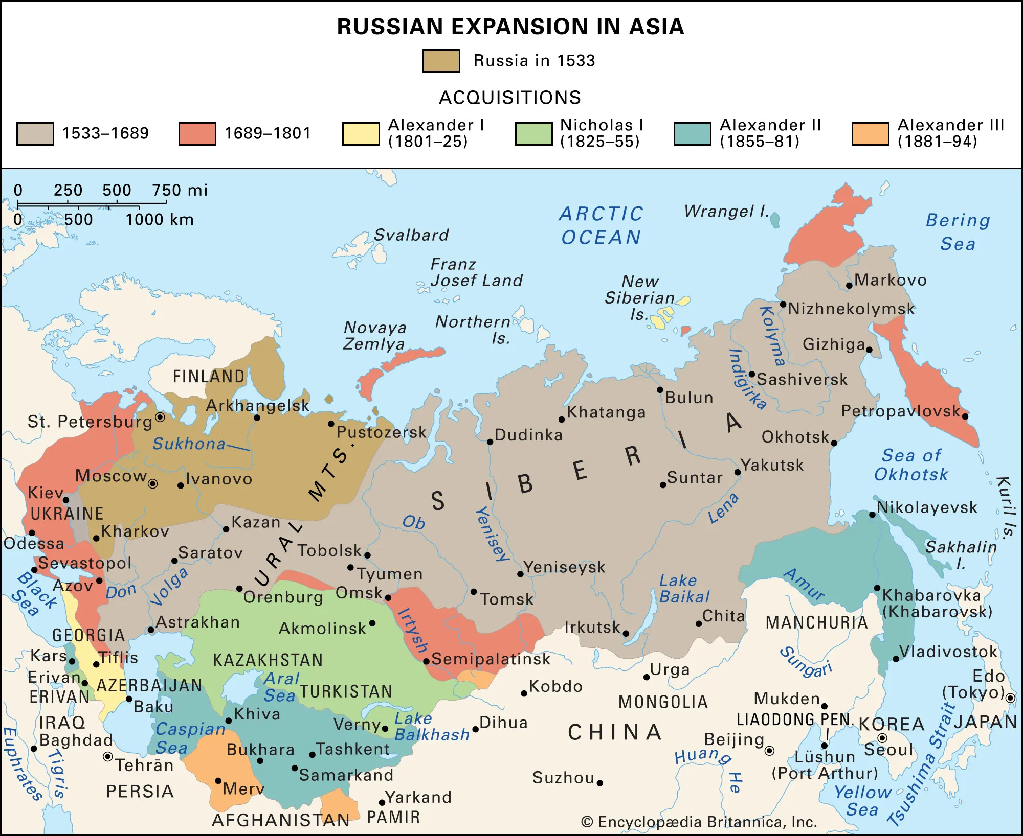
Fast forward to 1917, when the Russian Empire collapsed. At that point, this was the map of the Russian Empire:
Georgia declared its independence on May 26, 1918, and the First Republic of Armenia declared it on May 28, 1918.
Javakheti’s population was overwhelmingly Armenian at that point, but when the Russian forces retreated, Georgian troops swiftly went in and took control. The Armenian locals weren’t happy, but Armenia couldn’t do anything about it; it was busy fighting the Ottoman invasion of May–June 1918 (which included the famous Battle of Sardarabad in May 21-29). If Armenia had lost that battle, there may not have been an Armenia at all today.
So Georgia in a way took advantage of that situation, and also ended up taking the region of Lori (they claimed that region based on the fact that it was part of the georgian Kingdom of Kartli-Kakheti, which existed before the Russian annexation, from 1762 to 1801). In December 1918, there was a short “war” for Lori and Javakheti regions (both of which had Armenian-majority populations.).
The Javakheti region was actually included in the Armenian proposals for the Treaty of Sevres of 1920, but since the purpose of the treaty was to split up the Ottoman Empire, and Javakheti was part of the former Russian Empire, that claim was ignored.
Anyway, in 1920-1921, the Red Army invaded both countries, and now it was the ultimate time to decide who gets what. We know Karabakh was given to the Azerbaijanis, and we also know that Javakheti belongs to Georgia today, and Lori belongs to Armenia.
Why did the Soviets give Javakheti to the Georgian SSR? Well, one reason is that before the Russian Empire annexed Georgia, that land did belong to the Georgian Kingdom of Kartli-Kakheti. Secondly, just like with Karabakh, the Soviets wanted to intentionally mix ethnic groups across internal republic borders (a classic imperial tactic used to prevent unified nationalism and to create dependence on central authority). Thirdly, and probably most importantly, the Georgian SSR was a larger republic, with more resources, access to the Black Sea, and natural mountain barriers separating it from the Ottomans. So giving Javakheti to Georgia was a strategic move by the Soviets to secure loyalty from the Georgians.
4
So Zazas and Kurds are clearly ethnically different. There is no natural ethnic unity. They just unite over the fact of having a common enemy: the Turkish state. Kurdish politics in Turkey revolves around the demands of cultural, political, and linguistic recognition/rights/autonomy. And those are the same demands asked by Zazas, so it is not uncommon to see Zazas fighting for the PKK (Partiya Karkerên Kurdistanê, or Kurdistan Workers’ Party). Language differences and ethnic nuances don’t matter when dealing with a bigger threat. Political alignment is what matters. If you fought the Turkish state under a Kurdish banner, you were Kurdish politically. And this reinforced the idea that Zazas are just like Kurds, so they get bunched up in the same category. Some Zazas see this as a practical coalition and a political necessity.
It’s like in Canada if you actually want to vote for the Green Party, but you know they won’t win, so you vote for the Liberal or NDP party because at least they have a shot. Or if you want to vote for the People’s Party of Canada (PPC) but vote for the Conservative party instead.
Anyway. Zazas. Some Zazas aren’t happy with being part of the Kurdish grouping because their language is not Kurdish, their history is distinct, and they just see this inclusion as mirroring Turkish assimilation; they see Kurdish identity as another dominant umbrella swallowing a smaller group.
5
Byzantium wanted to absorb Armenian kingdoms without constantly fighting them. Territory is best taken through negotiation. But once you absorb a kingdom, you also inherit the problem of defending it. Eastern Anatolia is long, mountainous, and expensive to secure. So relocating a local king and his elite westward is a way to neutralize an independent power base on the frontier (this classic imperial strategy is explained next) and bring loyal Christian populations into regions where the empire can control and protect them more easily.
An independent power base means a local ruler, with land and soldiers and a loyal population, operating on the edge of an empire, where the empire’s grip is weakest. Because if politics change, they can switch sides, rebel, or negotiate with the enemy. So relocating a local king and his elite westward was a way to dismantle an independent power base on the frontier without open war. The population becomes integrated into Byzantine society, where they are welcomed. The Armenian army is broken and integrated into the Byzantine army. The Armenian nobility become imperial landholders, retaining status, rank and honor. All they lost was the ability to act independently.
So relocation creates dependency, integration, and loyalty to imperial structures. This is very clean.
And Cappadocia is one of those interior regions. It is better connected. It is safer than the extreme frontier. It already has Byzantine administration and military infrastructure. So placing them there benefits imperial stability.
By the way, the Byzantines weren’t doing charity work and just providing refuge for the Armenians from future Seljuk attacks. And Armenians were not random peasants in this context. Armenians had been integrated into Byzantine military and administration for centuries. Many Armenian nobles served the empire. They were valuable as soldiers and as organized communities. So resettlement is not only about removing them from danger. It is also about placing them where they benefit imperial stability.